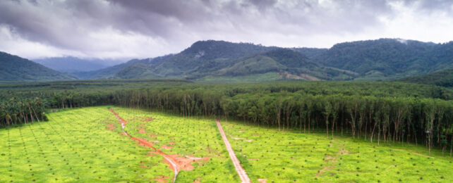
A massive effort to 'hand-map' undocumented roads has revealed the staggering extent of illegal or informal thoroughfares cut through forests of Indonesia, Malaysia, and New Guinea.
Using satellite imagery, researchers from Australia and Indonesia measured 1.37 million kilometers (851,000 miles) of thoroughfare – between three and seven times longer than the roads officially recorded in international databases for the same land area.
Within the surrounds of these missing 'ghost roads', they found, deforestation skyrocketed.
It's a troubling discovery from just one part of the world, Southeast Asia, which contains the largest combined expanse of tropical rainforest outside the Amazon and the Congo Basin.
And it comes at a time when the world really needs to be reining in deforestation to meet its biodiversity protection targets and avoid dangerous tipping points that could unleash catastrophic consequences if passed.
"Collectively, our findings suggest that burgeoning, poorly studied ghost roads are among the gravest of all direct threats to tropical forests," James Cook University applied ecologist Jayden Engert and colleagues write in their published paper.
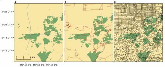
All up, it took the researchers and their team of 210 trained volunteers more than 7,000 hours to manually map roads they could spot on Google Earth satellite imagery of some 1.4 million square kilometers (more than 540,000 square miles) of land in the Asia-Pacific region.
Their analysis revealed a vast network of roads crisscrossing the islands of Borneo, Sumatra, and New Guinea. These roads measured 1.37 million kilometers in total length – between 3 and 6.6 times more than what is recorded in two international databases.
In some places, Engert told Carolyn Cowan of Mongabay, those databases had mapped less than 5 percent of the roads the eagle-eyed researchers and volunteers identified.
The missing 'ghost roads', as the researchers called them, included bulldozed tracks through untouched rainforests, which represented about one-third of unmapped roads, and informal roads on palm oil plantations, which accounted for between 35 and 45 percent of newfound roads.
Speaking with Nature's Benjamin Thompson, senior study author Bill Laurance said anyone extracting natural resources such as timber, minerals or endangered wildlife could be involved in carving these illegal, illicit and informal roads through forests or already-degraded lands.
"Truth is, there's a lot of illegal activity," said Laurance, a conservation biologist at James Cook University in Australia. "It's a real mixed bag, but it adds up to a lot when we put it all together."
Although the study did not look at who was responsible for building these roads, it shows that official records are seriously underestimating human impact in these areas.
Road building "almost always" preceded forest loss, a further analysis of satellite imagery between 1985 and 2020 found. In about 92 percent of 12 focus areas studied, each about 400 square kilometers in size, the nearby forest was logged as roads were being built, or soon after they appeared.
Protected areas also did little to safeguard against land clearing once those roads had been built. They contained a third as many roads as unprotected areas, but on a per-kilometer basis, roads inside protected areas led to nearly as much forest loss as roads outside them.
For protected areas to be effective safeguards they need to limit road expansion, the researchers say.
"The bottom line is, where the roads go is where the forest destruction happens. They're just hand-in-hand," Laurance told Thompson.
For the moment, Laurance says their team of volunteers still outperform the artificial intelligence models they tested to survey a wider area much faster than human eyes can. But that kind of automated system is urgently needed to protect tropical forests.
"Nothing else will keep pace with the contemporary avalanche of proliferating roads," the researchers attest.
Recent studies scouring satellite imagery of the Brazilian Amazon, Cameroon, and the Solomon Islands have detected 3 to 10 times more roads than official maps suggest, suggesting we're only just scratching the surface of the ghost road problem.
The study has been published in Nature.