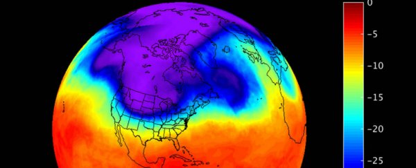
Stay warm, guys: newly released NASA images show the brutal polar vortex that's descended upon North America this week, and is predicted to bring record low temperatures to the US and Canada.
The data was captured by the Atmospheric Infrared Sounder (AIRS) instrument on board NASA's Aqua satellite, and it shows the air temperature around 5,500 metres or 18,000 feet above the ground, which is currently as low as –40 degrees Celsius (–40 Fahrenheit).
The NASA satellite measured the atmospheric air temperatures from December 1 to 11, and shows the dark blue and purple cold air moving eastwards across northern US and Canada.
On December 7, the frigid temperatures had moved into the plains states and were travelling into Colorado, Kansas, and Missouri. The cold is now moving from west to east, and it's looking like it's going to be a cold weekend, particularly for New England.
"That cold air shifted east on December 9 into the Ohio Valley and New England," writes NASA.
"On December 11, another trough of cold air was sweeping down from Canada into the northern plains and is expected to bring very chilly temperatures over the north central and northeastern US on December 14 and 15."
You can see the December 1 to 11 visualisation below:
But that's the temperature at the height of satellites.
Here's what those temperatures are going to feel like on the ground, with wind chill factored in. Yep, that's a nightmarish –29 degrees Celsius (–20 degrees Fahrenheit) over the northern Plains:
 Accuweather
"Forecast highs are expected to be 20 to 30 degrees Fahrenheit [11 to 17 degrees Celsius] below average over the north-central tier of the US," said National Weather Service's prediction service on December 15.
So what's causing all these subzero temperatures? The polar vortex is the name given to the swirling cold air pattern that's seen circulating the North Pole in winter.
When the polar vortex is strong, it's contained nicely in the Arctic circle and doesn't bother the rest of us. But scientists have known for years now that the polar vortex is weakening, which means that the vortex is more likely to break and send blasts of cold air down into the lower latitudes.
When those breaks happen - like right now - little vortices of cold air spiral out of the polar vortex and bring unseasonably icy weather further south.
Many #TropopausePolarVortices (#TPVs) comprise the #CircumpolarVortex. The TPV w/ lowest theta-DT on Earth fcast to be over Boston on Friday pic.twitter.com/se5wMzQoiL
— Philippe Papin (@pppapin) December 13, 2016
The last time this happened was in 2014, when it caused an extreme weather event in the northern US and Canada.
But new research has shown that the polar vortex has not only been getting weaker over the past 30 years, it's also shifting away from North America towards Europe and Asia during February each year.
That might sound like a good thing, but it could actually cause the east coast to get even colder and longer winters.
Despite these record-breaking lows, let's not forget that 2016 is still on track to be the hottest year on record globally.
And research has also found that the vortex break down is "closely related" to shrinking sea ice coverage in the Arctic - particularly in the Barents-Kara seas.
That link is still tenuous, but it doesn't change the fact that this November, temperatures around the North Pole were around 20 degrees Celsius (36 degrees Fahrenheit) warmer than they should be.
If nothing else, let's hope this current cold snap helps freeze some more sea ice in the Arctic, because we desperately need it.
Stay safe out there this weekend, kids.
