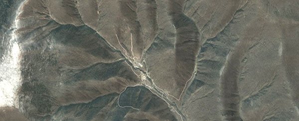
An underground test of what was claimed by North Korea to be a hydrogen bomb shook the surrounding landscape so violently, it changed the shape of an entire mountain.
Radar analysis of the area has revealed changes in the landscape caused by the blast, and they tell an alarming story.
The test was conducted early September last year, registering as a 6.3 magnitude tremor on seismographs in the surrounding region.
Based on the data, scientists have revealed that the mountain covering the site shrank by 0.5 metres (about 20 inches) and expanded by nearly 3.5 metres (11 feet).
For years, forensic seismology has allowed concerned states around the world to keep an eye on the ambitions of rogue nations to develop a nuclear arsenal by feeling for the tell-tale rumbles of a distant test explosion.
Monitoring the geological impact of underground tests from space, however, has been "underexploited" according to an international team of researchers.
"This is the first time the complete three-dimensional surface displacements associated with an underground nuclear test were imaged and presented to the public," says the lead author of the study, Teng Wang from Nanyang Technological University in Singapore.
Synthetic Aperture Radar (SAR) technology relies on a satellite's movement over an area to measure enough points to build a highly detailed 3D image of the landscape below, regardless of the weather conditions.
Data collected from Germany's TerraSAR-X and Japan's ALOS-2 radar imaging satellites were combined to create a before-and-after map of the area surrounding Mount Mantap, a 2,205 metre (7,234 foot) peak in North Korea's north-east.
Better make that 2,204.5 metres (about 7,233 feet).
Mount Mantap's nuclear test facility, Punggye-ri, has been the site of all six of North Korea's experimental blasts.
The previous detonations were nothing on the September blast, which, assuming an explosion depth of 450 metres, could have been the equivalent of 120 to 304 kilotons of TNT.
To put it in perspective, the 'Little Boy' atomic bomb that devastated Hiroshima in 1945 equated a mere 15 kilotons.
That size means the regime's claim that they were testing a small hydrogen bomb can't be ruled out, though the blast is still within the range of larger atomic detonations.
The combination of radar measurements and seismograph data paint a picture of a mountain under stress, possibly a feature of what has been termed 'tired mountain syndrome' - weakening caused by repeated underground explosions.
Already cracked and weakened by previous blasts, this last big bang vaporised granite to create a cavity about 50 metres (160 feet) across and fractured an even bigger volume of the surrounding geology.
The whole mountain would have lurched up by 2 metres (six feet) and out by nearly twice that, before settling again.
About 8.5 minutes after the initial tremor, detectors noticed a second, smaller shake, which was presumed to be a tunnel caving in, or perhaps the collapse of the cavity.
Whether it was this collapse or the settling of the stressed rock, what was left in its wake was a significantly shorter mountain.
Given the secretive nature of the program, it's impossible to know whether Punggye-ri is now non-functional.
In light of North Korea's recent pledge to denuclearise, it's easy to speculate that any progress in nuclear testing might now be more of a challenge for the state.
Upcoming talks between the US and North Korea might shed light on the situation. Meanwhile, the world is still watching.
Ever since a Comprehensive Test Ban Treaty was set in place in 1996, a watchdog organisation based in Vienna has relied on a mix of seismographs, infrasound instruments, and radionuclide 'sniffers' to detect signs of rogues and rule-breakers.
With such a dramatic demonstration of the contributions orbital imaging could make, we could be seeing satellites being added to their list of monitoring equipment.
"This study demonstrates the capability of spaceborne remote sensing to help characterize large underground nuclear tests, if any, in the future," says Wang.
This research was published in Science.
