NASA and NOAA jointly reported that 2016 was the warmest year on record. That's no surprise, as the first six months of the year were all exceptionally warm.
Yet the news is significant for what it says about global warming: before 2016, the 10 hottest years on record occurred since 1998. And last year was the third consecutive year a new global annual temperature record has been set.
Despite the ongoing record-breaking heat planet-wide, skepticism over anthropogenic, or human-made, global warming remains.
To some, the fact that meteorologists can't reliably forecast the weather days in advance is proof that scientists can't predict Earth's climate years or decades from now.
Why do scientists like myself have confidence in predicting record heat months in advance, and how do climate predictions differ from weather forecasting?
Weather forecasts based on motions of the atmosphere
Weather forecasts take into account the evolution of weather systems, including atmospheric pressure patterns. Atmospheric pressure is the force exerted by the weight of air molecules.
Areas where air is sinking have high pressure, and generally warm and fair weather. Low pressure systems, also known as cyclones, occur where air rises and typically produce cooler and wet weather.
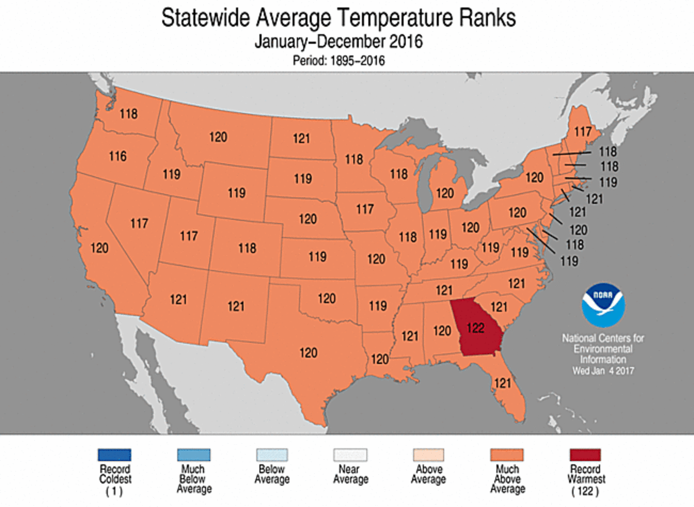
This map shows ranking for 2016 annual average temperature by state. Rankings refer to the 122-year period of record between 1895 and 2016.
A rank of 122 indicates record warmth - 2016 was the second-warmest year on record for the contiguous US.
 NOAA
NOAA
The accuracy of weather forecasts up to around two weeks out has improved greatly in recent years. But atmospheric systems don't persist long, and predictions beyond that time frame become much less accurate.
For example, forecasting the formation of low-pressure systems (cyclogeneis) and movement across the east coast of the US. presents a challenge.
A deviation from the forecast track of just 50 miles east or west can mean the difference between a blizzard, a windswept rainstorm or a near miss.
Similarly, forecasts of the amount of rain that will fall on a hot summer day can be very uncertain. When a forecast calls for 'isolated thunderstorms', factors controlling storm formation, such as daytime heating, moisture flow and upper-level winds, are expected.
But those factors evolve considerably during a given day, making it difficult to forecast total rainfall, particularly over a small area.
So it's hard to say if it will rain on your parade or the next town over – the term "pop-up" thunderstorm is apt.
That's not to say that warnings for severe storms should not be trusted. In this case, forecasts of severe weather are often made for larger geographical regions, and only when the conditions exist.
The factors that produce severe weather span a larger area compared with those leading to isolated storms. Technological improvements, including better radar and the use of supercomputers, are also leading to more accurate severe weather forecasts.
Role of ocean heat
In contrast to forecasts based on the movement of transient weather systems, climate predictions around temperature and precipitation, for example, use completely different sets of data.
To forecast several months to several decades into the future, scientists make use of ocean variations, other natural factors (solar variations, volcanic eruptions), and the overarching influence from rising greenhouse gas (GHG) concentrations in the atmosphere.
These variables evolve and exert their influence over months and years, unlike atmospheric pressure patterns which can change within hours or days.
One important factor with an effect of several months to about a year is El Niño, the periodic warming of ocean temperatures across the tropical Pacific.
This pattern of ocean warming and associated effects on the atmosphere exerts a strong influence beyond the tropics that can factor into climate predictions.
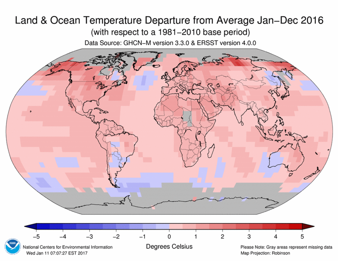
This map shows the blended land and sea surface temperature anomalies, or changes from historical averages, for 2016 in degrees Celsius:
 NOAA National Centres for Environmental Information
Data on ocean temperatures are critical because most of the sun's radiation striking Earth is absorbed by the world's oceans. Driven by this energy, oceans and the atmosphere distribute heat around the globe.
Years following an El Niño tend to be warmer than those with near-normal (also called neutral) or La Niña conditions. The presence of La Niña often results in a lowering of global temperature.
This tells us that the relative amount of heat in surface waters of the tropical Pacific can be used to predict global temperatures several months in advance, which is exactly what happened in forecasting last year's record temperature.
In December 2015 the U.K. Met Office predicted that 2016 would be record warm, between 0.72 and 0.96 degrees Celsius above the long-term (1961-1990) average.
Their announcement today that 2016 was 0.77℃ above average is within the predicted range.
In early 2016 Gavin Schmidt from NASA's Goddard Institute for Space Studies predicted that 2016 would be 1.3℃ above late 19th-century temperatures – remarkably close to today's reported 1.2℃ rise.
What about 2017? In its January 12 update, NOAA forecasted a transition from weak La Nina to neutral conditions through the first half of 2017.
La Niña's influence early in the year is central in predictions that 2017 will be slightly cooler than 2016, but still among one of the hottest years on record.
 UK Met Office
It should be added that the record 2016 warmth was not due to El Niño alone. Indeed, El Niño years are becoming warmer, as are those with a La Niña, due to the overall warming trend from rising GHG concentrations.
Combined influence of human and natural factors over time
Beyond ocean effects, other natural factors are known to influence the rate of warming. Large volcanic eruptions, particularly those in the tropics, can have a cooling effect globally by blocking solar radiation.
For example, the eruption of Mt. Pinatubo in 1991 resulted in a drop in the average global temperature of about 1 degree Fahrenheit (0.6℃).
Cooling, however, is typically short-lived and ends when the volcanic aerosols – the small particles that block sunlight – rain out.
Variations in solar output can also influence climate. The observed warming trend over recent decades, however, cannot be attributed to changes in the Sun.
The impact of solar variability on climate change is evident, but the effect of GHGs has been proven much more considerable in the short run.
Projections of warming at longer time scales – multiple decades or longer – are based on simulations by climate models and our understanding of how sensitive the climate system is to future increases in atmospheric GHG concentrations.
What models have shown is that future warming is expected to be dominated by the rising GHG levels as compared with the variations from internal ocean variability and other natural factors.
The warming will be amplified by feedbacks involving the carbon cycle, atmospheric moisture and other factors. For example, water vapor is a potent GHG, so rising atmospheric moisture amounts will enhance warming.
Also, emissions from the Arctic are a particular concern and threaten to switch the Arctic from a sink of carbon to a source.
Sixteen of the 17 hottest years have occurred this century. There is an overwhelming scientific consensus that human actions are warming the planet.
At the same time, we continue to improve weather and climate predictions, which will lead us to a deeper understanding of climate system behavior over different time periods and across multiple spatial scales.
This research will improve the accuracy – and confidence – in projections for the future.
Michael A. Rawlins, Extension Associate Professor, University of Massachusetts Amherst.
This article was originally published by The Conversation. Read the original article.
![]()
