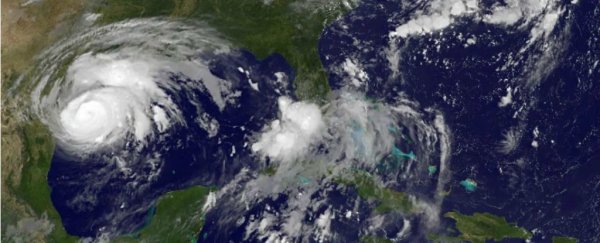
As a major hurricane has made landfall in the United States for the first time since 2005, we may be fated for another debate about how climate change does, and doesn't, affect these kinds of events.
It would be strange to ignore the role of a changing climate when it comes to hurricanes, because they themselves have a climatology - that is, certain conditions make them more likely to form and also to worsen.
But it's August, and the Gulf of Mexico can certainly sustain fierce hurricanes this time of year. Singling out Harvey as some kind of climate-driven anomaly would be a big mistake.
Yet the climate influence is still something we need to consider, said Kerry Emanuel, a hurricane theorist at MIT.
"My feeling is, when there's a hurricane, there's an occasion to talk about the subject," he said. "But attributing a particular event to anything, whether it's climate change or anything else, is a badly posed question, really."
Scientists like Emanuel prefer to speak about climate-related factors that can worsen hurricanes, like Harvey, in specific ways - and about the ways in which certain attributes of Harvey seem consistent with what to expect, more generally, in a warming climate, even if they can't be causally attributed to it.
The biggest in the first category is atmospheric moisture. Harvey is expected to unleash rain-induced flooding that the National Hurricane Center recently described as "catastrophic", with rainfall in some specific locations reaching 35 inches as the storm stalls out along the coast.
This particular storm track and unfortunate expected behaviour is what makes for the main rainfall risk. But scientists say that in general, storms will rain more in a warmer climate.
As the world warms, evaporation speeds up. So on avg there's more water vapour for a storm to sweep up & dump now, compared to 70 years ago. https://t.co/M4R9OFFZt9
— Prof. Katharine Hayhoe (@KHayhoe) August 24, 2017
"The storm is a bit more intense, bigger and longer lasting than it otherwise would be," added Kevin Trenberth, a climate researcher with the National Center for Atmospheric Research in Boulder, Colo.
And then there's sea level - it's higher along the Texas coast than it was 100 years ago or more. At least part of that is because of climate change and its melting of ice and swelling of ocean water - though there are other factors in the mix, too, such as the subsidence of land.
Sea level matters for storm surge, one key destructive aspect of any hurricane.
"New York, when Sandy hit, the sea level was already about a foot higher than it was 100 years earlier," Emanuel said. "So if Sandy had hit in 1912, it probably would not have flooded Lower Manhattan."
Another way that climate change affects hurricanes is that it is expected to lead the average storm to be more intense.
And sure enough, in 2015 we saw what may well have been the most intense storm ever measured - Hurricane Patricia in the Northeast Pacific, with maximum sustained winds of 213 miles per hour (343 km/h).
That's not so relevant of a trait for Harvey, though, as it falls well shy of the most intense hurricanes before making landfall.
Finally, there's an aspect that's noteworthy about this storm and also relevant in a climatic context, in the sense that it's something we should expect to see more of: its rapid intensification.
On Thursday morning, Harvey was a tropical storm with 45 mile per hour (72 km/h) winds. By Friday afternoon, it was at the top end of Category 2 strength, with 110 mile per hour (177 km/h) winds, and expected to strengthen a bit more before landfall.
There have been hurricane intensifications much more rapid and alarming than this - like Hurricane Wilma in 2005 and Hurricane Patricia in 2015 - but in general, any major change in storm strength close to land is a huge risk because people have little time to prepare for it.
And Emanuel has published research suggesting that hurricanes will be capable of intensifying more rapidly in warming climates.
In a study in the Bulletin of the American Meteorological Society published earlier this year, he found that:
… a storm that intensifies 60 [knots] in the 24 [hours] just before landfall, occurring on average once per century in the climate of the late twentieth century, may occur every 5–10 years by the end of this century, while 24-[hour] prelandfall intensifications of 100 [knots], which are essentially nonexistent in the late twentieth-century climate, may occur as frequently as once per century by the end of this century.
Even holding the overall basin frequency constant, the incidence of storms that intensify rapidly just before landfall increases substantially as a result of global warming.
Fortunately, it appears that Harvey's slow speed of movement is muting its potential for greater rapid intensification, Emanuel noted. Storms churn up cold waters from below, and so weaken themselves.
They have more ability to do that if they're moving slowly across a stretch of warm ocean than if they're moving rapidly. That could mean less of a storm surge and weaker winds than the storm might have produced otherwise.
So in sum: Harvey's expected damage will mainly be attributable to the simple fact that it's a strong summer hurricane that is not only going to hit the United States but will do so along an unfortunate path and is expected to linger, dumping huge amounts of rain.
But the climatic and sea level context is also shaping this storm, as is inevitably true for other hurricanes as well. We should neither overplay that nor forget it.
2017 © The Washington Post
This article was originally published by The Washington Post.
