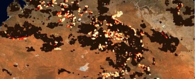
The devastating scope of wildfires raging in Australia's Northern Territory for the past two months has now been graphically depicted in an animation.
Earth observation scientist Robbi Bishop-Taylor of Geoscience Australia shared the timelapse video on X/Twitter, with an explanation of just how massive the fire ravaged area is.
According to authorities, this fire season has been the most severe in decades, consuming more than 12.8 million hectares (31.6 million acres) of land in just two months.
It comes as fires continue in the Australian state of Queensland, with residents told to flee their homes last week.
The scale of the fires currently burning across northern Australia is pretty unfathomable.
— Dr Robbi Bishop-Taylor 🦋 (@SatelliteSci) November 3, 2023
This animation visualises just the last two months of fire captured by #DEAHotspots - for context, the map covers an area larger than France, Spain and Germany combined... pic.twitter.com/YBkOQP5xCK
An El Niño weather event, which is linked to extreme occurrences like wildfires, has precipitated an especially high-risk bushfire season.
Temperatures in Northern Australia have been scorching, with some areas receiving severe heatwave warnings. Dry and warm weather creates ideal conditions for fires to start and spread.
Parts of Northern Australia have been unusually dry and windy, and strong winds can fan the flames, causing them to spread rapidly.
Two weeks earlier, Bishop-Taylor shared a more zoomed-in example to show how wind is influencing the progression of some of the fires:
Multiple fires tracing paths across the landscape near Willowra in Australia's Northern Territory.
— Dr Robbi Bishop-Taylor 🦋 (@SatelliteSci) October 12, 2023
(Captured by @GeoscienceAus #DigitalEarthAU Hotspots over the past two weeks) pic.twitter.com/1lbSO602ty
The risk has also increased due to above-average rainfall earlier in the year, meaning more vegetation that can fuel fires. Once the heat sets in, the drying soil makes vegetation more flammable and it's easier for fires to start and spread.
A fiery tornado was captured last month wreaking havoc in remote Tennant Creek, fueled by the hot, windy, and dry conditions.
Watch this ‘firenado’ tear through an outback at Tennant Creek in Australia’s Northern Territory as multiple bushfires ravaged the area on Oct 27
— Earth42morrow (@Earth42morrow) November 4, 2023
VC: HayesCook/ Silver Bridle Contracting via FB#Australia #wildfire #ForestFire #fire #Oz #TennantCreek #Jungle #firewhirl #Tornado… pic.twitter.com/CoQ2Pu3jGr
The combination of factors has created a tinderbox of conditions in northern parts of Australia. The surge in fires, some believed to be deliberately lit, has had a devastating impact on the environment and communities in the region.
It follows a disastrous fire season in the Northern Hemisphere, where temperature records were shattered by extreme heat.
Amid summer heatwaves in Asia, Europe, and North America, accelerated by human-made climate change, experts predicted 2023 could be the hottest year on record.
Across Europe, this year's fires sent 20 million tonnes of carbon dioxide into the atmosphere. Italians were warned they would be facing "the most intense heatwave of the summer and also one of the most intense of all time".
Greece was ravaged by numerous fires, which its government puts down to climate change, including the largest ever recorded in the EU, in August.
We can expect the number of wildfires to increase as Earth warms and the climate shifts, producing even more catastrophic fire conditions.
