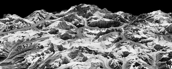
Just under half a century ago a system of satellites codenamed Hexagon was circling the globe and snapping high-resolution shots of the changing landscape… not to mention a Russian airfield or two.
With the Cold War long melted, those images were declassified back in 2002, providing rich pickings for all kinds of research. Now scientists have used these pictures to present a startling new perspective on the Himalaya's vanishing glaciers.
A team of US researchers from Columbia University and the University of Utah have made detailed measurements on changes to the thickness of ice in the Himalayas between two time periods; from 1975 to 2000, and then 2000 to 2016.
In some ways, what they found might not come as a great shock, if you've been paying attention to the climate crisis.
"It looks just like what we would expect if warming were the dominant driver of ice loss," says the study's lead author Joshua Maurer from Columbia University's Lamont-Doherty Earth Observatory.
The team stitched together galleries of images of the Himalayas taken by the Keyhole-9 'Hexagon' photographic reconnaissance satellites, ending up with an overview of some 650 glaciers spanning the famous mountain range.
They then developed a process to turn the 3D map into a form that provided information on elevations.
By comparing the results with modern stereo satellite imagery from NASA's Advanced Spaceborne Thermal Emission and Reflection Radiometer (ASTER) program, Maurer and his team could calculate annual changes to ice coverage.
Since the turn of the millennium, glaciers have thinned by an average of just under half a metre (roughly 1.5 feet) per year. Over the preceding decades, that loss was half; closer to 22 centimetres, or just under 10 inches.
That's averaged out as well. While some glaciers at higher elevations are holding steady, there are rivers of ice closer to sea level that are losing on average 5 metres (16 feet) a year.
Of course, glaciers can thin out over time for a number of reasons. Lower precipitation, for example, or fine particulates from pollution increasing localised warming by darkening the ice and absorbing sunlight.
These factors can almost certainly contribute to the melting of large patches here and there, but the sheer scale of the change implies a more global effect.
To test their suspicions, the team also compiled data on temperatures taken by ground stations and compared these with rates of melting across the map.
Sure enough, both sets of figures lined up neatly enough to reveal that our warming planet can certainly account for the ice loss.
"This is the clearest picture yet of how fast Himalayan glaciers are melting over this time interval, and why," says Maurer.
Further west, mountain ranges such as the Alps have attracted attention for accelerated melting of their icy peaks in the 1980s.
While it took a little longer to come up to speed, it's now clear the Himalayas are rocketing ahead. Given the area they cover and their position, we can expect the melting of their glaciers to be a catastrophe of immense proportions.
Seasonal snowmelts contribute significant quantities of water to major river systems such as the Indus, where hundreds of millions rely on its flow and volume for drinking water, farming, and hydroelectricity.
Increased melting might temporarily be a boon, but in the long term, millions of people will face an increasing risk of water crisis.
Tragically, pooling meltwater is putting communities at greater risk of cataclysmic flooding as elevated lakes burst at the seams, sending walls of water crashing downhill.
In the 1970s, US authorities launched the Hexagon system of spy satellites partially in hope of having advanced warning of a building global threat.
Thankfully, that particular type of threat never eventuated. But now, nearly 50 years later, the same library of pictures has given us strong evidence of a much more serious threat. This time, it's real.
This research was published in Science Advances.
