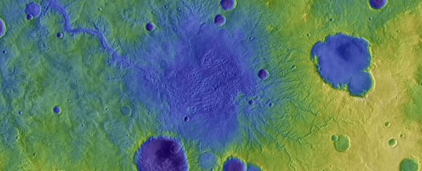
It may be dry as desert bones these days, but Mars was once so wet that entire landscapes were shaped by running water.
Wild floods thundered across the red ground, gouging chasms in the Martian surface and dumping vast quantities of sediment that changed the shape of the landscape. And, in contrast to such landscape-changing water movement on Earth, they happened quickly, on timescales of just a few weeks.
These floods were from overflowing lakes filling craters on the Mars surface, and were much more common than we thought, according to a newly published study.
"If we think about how sediment was being moved across the landscape on ancient Mars, lake breach floods were a really important process globally," says geoscientist Tim Goudge of the University of Texas at Austin.
"And this is a bit of a surprising result because they've been thought of as one-off anomalies for so long."
In comparison to Earth, Mars is pretty riddled with craters. That's because processes such as erosion and tectonic activity have erased a lot of the impact craters from Earth's surface; as a result, the two planets have very different surface profiles. On Mars, the profusion of ancient craters meant that, billions of years ago, when the red planet was still wet, crater lakes were very common.
We know that, when these lakes became too full, they would breach the crater walls and cause devastating floods in the surrounding landscapes. Previous research studying satellite imagery has revealed some of these breached craters, and the deep valleys their floods carved into the landscape nearby.
This time, Goudge and his team took a different approach. Rather than examining individual craters and their surrounds, their study includes 262 breached crater lakes, and how they shaped the surface of Mars globally.
We have a lot of detailed imagery covering the surface of Mars, thanks to years of satellites orbiting the red planet. From this, we have existing maps of river valleys across the globe. The researchers took these maps and placed the river valleys into two categories: those physically connected to a crater breach, and those that formed away from craters, suggesting a more gradual formation process.
In addition, they calculated the volumes of the eroded valleys based on depth and width measurements obtained by satellite measurements – and made a surprising finding.
The valley systems gouged out by crater breach floods only accounted for 3 percent of the length of the valleys eroded by water on the Martian surface. But this 3 percent was much, much deeper than the other river valleys – crater flood valleys had a median depth of 170.5 meters (559 feet) compared to the 77.5-meter (254 foot) median depth of the gradual valleys.
With all the figures added up, the crater flood valleys accounted for at least 24 percent of the volume of river valleys on Mars.
Because this effect was so sharp, the team found that it could have had a lasting impact on the surrounding landscape and river systems, despite the brief duration of the floods themselves. The deep valleys carved out by the floods would have dropped the local base level, establishing new lows for water flows. This would have a significant effect on pre-existing river systems.
All this could explain some features of the topography of Mars that are usually attributed to climate, such as convex fluvial valleys, the researchers said. This topography could instead be a response to disruptions to the base level caused by crater breach flooding.
It also highlights how important it is not to assume that processes here on Earth will occur the same way on other planets. Although the Solar System's rocky worlds have many similarities, their differences can be immense.
"When you fill [the craters] with water, it's a lot of stored energy there to be released," Goudge said. "It makes sense that Mars might tip, in this case, toward being shaped by catastrophism more than the Earth."
The research has been published in Nature.
