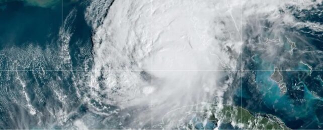
After an unseasonably quiet August, the Atlantic hurricane season is ramping up. Hurricane Milton, now a Category 4, is forecast to land over Florida Wednesday night as the state is still cleaning up the damage from Hurricane Helene, which hit less than two weeks prior.
These back-to-back storms aren't the end of what we may see this year, experts told Business Insider.
"I wouldn't be surprised if we see a few other storms forming before the season ends," Kelly Núñez Ocasio, assistant professor with Texas A&M University's Department of Atmospheric Sciences, said.
What's going on with this year's hurricane season
October's sudden uptick in storms isn't a surprise to scientists. The National Oceanic and Atmospheric Administration predicted a high chance of a more active season this year than normal in May and reiterated its prediction in August after the season kicked off to a violent start with Hurricanes Beryl, Debby, and Ernesto.
Then hurricane season went quiet. There were no named storms between August 13 and September 3 – typically around when hurricane season is reaching its peak. As Hurricanes Helene and Milton suggest, it was the calm before the storm.
Weather patterns – like Africa's monsoon season and La Niña – that typically fuel hurricanes during peak season, were behaving unexpectedly over the summer, which likely contributed to the unseasonable lull. Those patterns have since shifted, which could bring more storms in the coming weeks.
Over the summer, Africa's monsoon season, which feeds the Atlantic with moisture and waves for forming storms, made an unusual move and migrated north to drier conditions where storms are less likely to form, according to a September report from Colorado State University's Department of Atmospheric Science.
La Niña, the periodic cooling of ocean temperatures in the tropical Pacific, typically reduces vertical wind shear in the tropics, which can help Atlantic storms form and grow. This year, La Niña was forecast to begin in August but it's only just now showing signs of ramping up.
"We're kind of sliding into La Niña now," Matthew Rosencrans, the lead hurricane season forecaster with the NOAA's Climate Prediction Center, told BI. The West African monsoon has also settled back toward its typical position, he added. Both are signs that hurricane season is not over and more storms could be on the horizon.
More storms to come
At the start of the Atlantic hurricane season in June, NOAA predicted up to 13 hurricanes by the season's end. So far, there have been nine.
Conditions, especially in the Gulf of Mexico, have been ripe for storms over the last few weeks. Rosencrans expects those conditions to shift south toward the Caribbean in the coming days, as a result of La Niña ramping up.
That could also shift storm formation slightly more south, according to NOAA's Global Tropics Hazards Outlook for the rest of October.
The Gulf is still in a unique place this year for storms. Every square inch of the Gulf of Mexico has abnormally warm surface temperatures, high enough to support tropical storm development, Rosencrans said.
This can also help storms rapidly intensify like Hurricane Milton. "Those warm waters act as fuel for the hurricanes, and the warmer the water, the faster these storms can intensify," Stephanie Zick, an associate professor for Virginia Tech's Department of Geology, told BI in an email.
It's not just storms over the Gulf and Caribbean regions, though.
Núñez Ocasio expects to see more storms form over the Atlantic in the coming weeks, since Africa's monsoon is still active and has shifted into a better position to spin up storms.
Hurricane season may be shifting
This year's unusual hurricane season may be a sign of things to come.
In a study published in June, Núñez Ocasio and colleagues simulated how increasing levels of moisture in the atmosphere – a consequence of climate change – may affect Africa's climate and Atlantic hurricanes in the coming years.
Typically, more moisture can lead to more storms, but the study found a tipping point where too much moisture can cause an abnormally wet and active African monsoon. That shifts the energy north away from the zone where it would normally spark a tropical storm – similar to what happened this year.
"What the study shows is that there's a delay," in hurricane formation, Núñez Ocasio said, adding that, "we may start to see a shift in the peak of the Atlantic hurricane season."
Rosencrans said that there's a large window for peak hurricane season, and the peak varies each year. This year's peak appears to be a couple of weeks later than average, but he's yet to see a trend that would confirm a concrete shift.
"What we have to do is prepare, because in the end, what we do is to save life and property," Núñez Ocasio said of herself and the hurricane research community.
This article was originally published by Business Insider.
More from Business Insider: