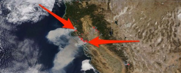
It's peak wildfire season in California, where more than a dozen blazes ignited on Sunday.
Officials have yet to determine the origin of these fires, most of which are in Northern California. But dry, powerful "Diablo winds" that blew in overnight stoked and further spread the infernos.
Satellites in space are looking down on the disaster, which has left more than 10 people dead.
Several large and as-yet uncontained wildfires have burned 1,500 homes and more than 53,000 acres in Napa County, as well as thousands of additional acres in Sonoma County - both of which comprise California's wine country.
This animation layers the views from three different satellites, from late Sunday night through Monday afternoon, which is the latest available image data.
Blue dots and red blobs (middle) show the fires growing, while daytime views reveal extensive clouds of smoke billowing over parts of San Francisco and out over the Pacific Ocean.
The animation comes via an interactive satellite-image-and-mapping tool built by Colorado State University's Cooperative Institute for Research in the Atmosphere.
While the tool can summon data from multiple satellites and instruments, the images shown here come from the National Oceanic and Atmospheric Administration's powerful new GOES-16 weather satellite.
The satellite captures a full view of the western world every few minutes (shown below during the same time period).
The images can be taken in visible light, as well as near-infrared and infrared light - wavelengths that can take thermal images of fires even when it's dark.
This article was originally published by Business Insider.
More from Business Insider:
