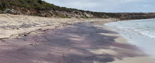
Usually, when something in nature turns pink, it's not a good sign. But weird pink sands washing up on South Australian beaches have uncovered an ancient Antarctic mountain range thought to be buried under ice.
When streaks of pink first appeared in the sands at Petrel Cove, a remote beach that meets the Southern Ocean, scientists in Australia quickly worked out what the colored sand was made of, a mineral called garnet, but were surprised by its age and where it originated from.
"This journey started with questioning why there was so much garnet on the beach at Petrel Cove," says University of Adelaide geologist Jacob Mulder.
"It is fascinating to think we were able to trace tiny grains of sand on a beach in Australia to a previously undiscovered mountain belt under the Antarctic ice."
Earth's crust is constantly eroding and reforming, with loosened sediments whisked away on the wind and waters getting deposited elsewhere to form new lands. If geologists are lucky, they can draw connections over huge distances and long stretches of time between deposits of similar ages with alike properties.
Garnet is a fairly common mineral, deep red in color. It crystallizes at high temperatures, usually where large mountain belts grind upwards out of colliding tectonic plates. This makes it arguably the most important mineral for deducing how and when mountains formed, as the crystals' presence indicates the pressure and temperature history of the metamorphic rocks in which they form.
The team's lutetium-hafnium dating showed that some of the garnet found at Petrel Cove and in nearby bedrock formations matched the timing of local mountain-forming events in South Australia.
But their results indicate it mostly formed around 590 million years ago, some 76–100 million years before the Adelaide Fold Belt took shape, and billions of years after the Gawler Craton crustal block formed.
"The garnet is too young to have come from the Gawler Craton and too old to have come from the eroding Adelaide Fold Belt," explains Sharmaine Verhaert, a geology graduate student at the University of Adelaide who led the investigation.
Instead, the garnet likely formed at a time when the South Australian crust "was comparatively cool and non-mountainous," Verhaert says.
Garnet is typically destroyed by extended exposure to waves and currents, so the researchers also figured it probably surfaced locally, even if it originally formed millions of miles away, millions of years ago.
Their investigations revealed a grand solution, one that links the pink sands at Petrel Cove to layers of nearby glacial sedimentary rock and with distant garnet deposits previously found in an outcrop of the Transantarctic Mountains in East Antarctica.
The rocky outcrops protrude from a thick ice sheet that otherwise completely conceals the underlying area, making it impossible to sample the geology beyond the exposed tips of a mountain range that is thought to lie beneath. The hidden mountain belt is thought to be 590 million years old, just like the garnet analyzed in this study, but researchers haven't been able to get a good look at it.
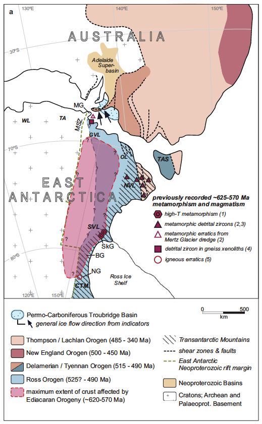
Joining the dots with ice-flow indicators in the South Australian glacial sedimentary rocks, Verhaert and colleagues think that garnet-rich glacial sands were ground out of the Antarctic mountains – which are yet to see the light of day – by an ice sheet moving north-west during the Late Palaeozoic Ice Age, when Australia and Antarctica were connected in supercontinent Gondwana.
"The garnet deposits were then locally stored in glacial sedimentary deposits along the southern Australian margin," explains University of Adelaide geologist Stijn Glorie, "until erosion [once again] liberated them and the waves and tides concentrated them on the South Australian beaches."
An epic journey across land and time.
The study has been published in Communications Earth & Environment.