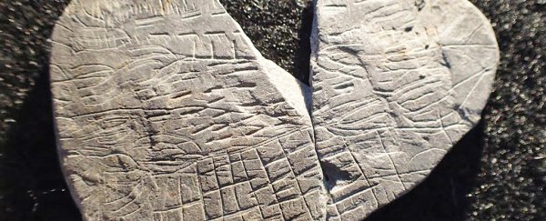
Archaeologists in Denmark have uncovered what they think is one of the oldest maps ever made: a series of markings on a 5,000-year-old rock that seem to depict the positioning of fields and paths.
The fragmented stone, measuring just 5 centimetres (1.97 inches) across and dated to roughly 2700-2900 BC, is part of a haul of artefacts that have been discovered on the island of Bornholm in the Baltic Sea, including strange ritualistic stones depicting the Sun.
In fact, according to the team from the National Museum of Denmark, the damaged stone was probably crushed during one of these Sun-worshipping rituals carried out by Stone Age farmers. It's currently in two pieces, with the missing third piece still yet to be found.
"These are not accidental scratches," one of the researchers, Flemming Kaul, told The Local. "Some of the lines may be reproductions of ears of corn, or plants with leaves."
Kaul added that if the stone is indeed a map, it would be "something very unique" and "without parallel".
Stones previously found at the same site show what appear to be pictures of the Sun and the Sun's rays. It's thought that the ceremonies they were used in were carried out to try and bless the fertility of the land, the archaeologists say.
This new find is different: it was uncovered at a Neolithic shrine excavation alongside nine other 'map stones' this summer, but this particular relic is the most complex.
"We all agree that it looks like some sort of a map – not a map in our modern sense, but a stylised map," Kaul explained to Tom Metcalfe at Live Science.
"And I could see some similarities with rock carvings from the Alps in northern Italy, dated to the same period of time, which are interpreted as symbolic landscapes – and that is what I believe we have found now."
Settlers in the area are thought to have arrived around 3500 BC, building houses of wood and stone and farming wheat, barley, beans, peas, and a plant called flax, used to make linen for clothes.
With the fields and the rock carvers now long gone, the researchers acknowledge that the markings on these stones are open to interpretation, but Kaul and his team are convinced that we're looking at an ancient map.
Many of the earliest known maps charted the stars rather than the Earth, with a painting on the walls of the Lascaux cave dating as far back as 16,500 years ago – many thousands of years before our modern age of satellite images and smartphone GPS signals.
Meanwhile, stone carvings depicting the position of mountains, rivers, and ponds have previously been found in Spain, and are thought to be almost 14,000 years old.
The Bornholm find can't compete with that, but it's still an exciting discovery.
The similarities Kaul notes between the Danish stones and rock carvings in sites like Valcamonica in Italy are suggestive of Stone Age settlers sharing similar beliefs about the power of the Sun to bless the land with crops.
"When you also look at the Italian material, then it gives you a feeling that these map stones are not just isolated phenomenon," he says, "but that we are looking at a trend of a general European development here, and also in a religious or spiritual sense."
The research has yet to be published in a peer-reviewed journal, so we need to take the researchers' interpretations with a grain of salt until they can be independently verified, but an article about the discovery appeared in the October issue of the Danish archaeological magazine Skalk.
