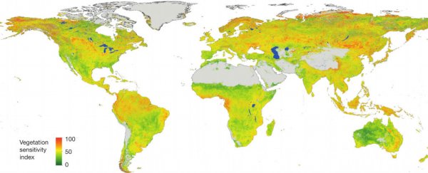
A map showing which areas of the globe are likely to see the most dramatic effects of climate change has been produced by an international team of scientists using a new metric called the Vegetation Sensitivity Index.
Based on satellite imagery data collected between 2000 and 2013, the index measures three different factors: air temperature, water availability, and degree of cloud cover. By charting how these variables are changing over time, together with the level of vegetation ground cover during the same period, the researchers have been able to identify the regions that are most sensitive to an evolving climate.
"Our study provides a quantitative methodology for assessing the relative response rate of ecosystems – either natural ones or those with a strong anthropogenic footprint, to climate variability," says first author Alistair Seddon from the University of Bergen in Norway.
"This kind of information can be really useful for national-scale ecosystem assessments… Even more interesting is that as satellite measurements continue and so as the datasets get longer, we will be able to recalculate our metric over longer time periods."
The whole Earth was mapped in a grid of 3.2-square-km (2-square-mile) blocks, with each one marked from most to least sensitive. Some areas, such as the Sahara or Antarctica, were labelled as completely barren or ice-covered.
Areas shown in green on the map have a lower sensitivity to climate change – that means they're better able to adapt to variations in temperature, water availability and cloud cover.
The areas marked in red, on the other hand, are highly sensitive to climate change and have been hit hard by evolving weather patterns. The northern half of South America and the Scandinavian region of Europe are among those showing most red, for example.
Mountainous regions and rainforests – both finely balanced ecosystems – are particularly susceptible to climate change, report the scientists. "Identification of large-scale metrics to quantify ecological responses to climate change remains a vital strategy for global ecosystem assessment," concludes the paper. "The next challenge is to understand the underlying causes and ecological processes that lead to these patterns."
The researchers will continue to develop the map in the future, getting a better idea of the long-term effects of climate change on different parts of the world.
The study has been published in Nature.
