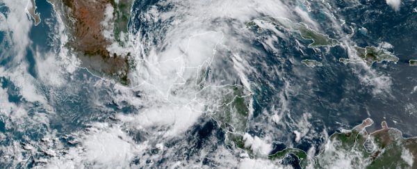
Just two days into the 2020 Atlantic hurricane season, Tropical Storm Cristobal was churning in the Gulf of Mexico.
It was the third Atlantic storm powerful enough to get a name this season; no other year on record has seen three named Atlantic storms so early. On average, the third storm forms around August 13, according to AccuWeather.
The World Meteorological Association assigns names to storms whose wind speeds exceed 39 mph (63 km/h) – that's the threshold at which a cyclone is considered a tropical storm. Cristobal's winds topped that on Tuesday; then it struck the Bay of Campeche on Wednesday. The storm could build to hurricane strength as it approaches the US Gulf Coast.
The National Oceanic and Atmospheric Administration (NOAA) has projected that this hurricane season will be "above-normal" in the Atlantic Ocean. That means six to 10 hurricanes, with three to six of those reaching Category 3 or higher (that's considered a "major hurricane").
An average season sees roughly six hurricanes, with three becoming major. But the Atlantic Ocean has been producing highly active hurricane seasons since 1995, according to NOAA.
This season began on June 1. But by then, Tropical Storm Arthur had already skimmed the North Carolina coast and Tropical Storm Bertha made landfall in Charleston, South Carolina.
Before NOAA's projection for the season, more than a dozen forecasts from other government agencies, research institutions, and private companies had projected that storm activity would be "above average," with at least six hurricanes, according to CNN. Some groups are even expecting an "extremely active" season, with more than nine hurricanes.
"In general, the consensus between seasonal hurricane forecasts this year is greater than it has been the past few years," Phil Klotzbach, a research scientist at Colorado State University's Department of Atmospheric Science, told CNN.
Storms like Cristobal are increasingly likely to become major hurricanes
The odds of any tropical cyclone becoming a major hurricane are increasing as human activity warms the globe.
A study from researchers at NOAA and the University of Wisconsin-Madison found that each new decade over the last 40 years has brought an 8 percent increase in the chance that a storm turns into a major hurricane.
"We have a significantly building body of evidence that these storms have already changed in very substantial ways, and all of them are dangerous," James Kossin, an atmospheric scientist at NOAA and the study's lead author, told the Washington Post.
The findings, published in May, were based on 40 years of satellite data.
Hurricanes are getting stronger and wetter because because climate change is causing ocean and air temperatures to climb – 2019 was the second-hottest year on record, and it closed the hottest decade ever recorded. Hurricanes feed on warm water.
What's more, higher water temperatures lead to sea-level rise, which increases the risk of flooding during high tides and storms surges. Warmer air also holds more atmospheric water vapour, which enables tropical storms to strengthen and unleash more precipitation.
"Almost all of the damage and mortality caused by hurricanes is done by major hurricanes," Kossin told CNN. "Increasing the likelihood of having a major hurricane will certainly increase this risk."
This article was originally published by Business Insider.
More from Business Insider:
