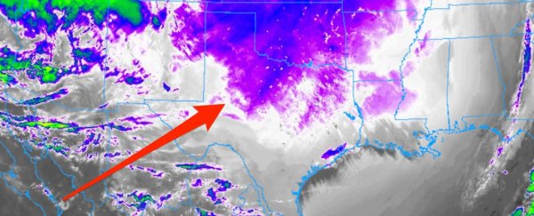
The severe winter storm raging through the southern US brought such extreme cold that it confused weather satellites monitoring the situation.
On Tuesday, the cold air advancing south from the Arctic chilled the ground so much that one monitoring satellite mistook the ground for tops of clouds, which are usually much colder than surface temperatures.
The phenomenon was first pointed out by Washington Post meteorologist Matthew Cappucci.
A similar effect was seen over Canada on February 10, where it was highlighted by the local news channel WROC TV in Rochester, New York.
The satellite in question is called GOES-East. It uses infrared sensors to measure temperatures at the top of clouds to plot them.
Typically, the clouds are colder than the ground surface. The satellite's algorithms use this assumption to outline cloud cover from space, even at night.
Capucci tweeted a video illustrating the effect:
This is incredible.
— Matthew Cappucci (@MatthewCappucci) February 16, 2021
That purple bleeding south you see isn't from clouds – extreme #cold is expanding as night commences, tricking satellites over #Texas and #Oklahoma into thinking there are clouds.
Lake-effect snow too from Lakes Conroe and Livingston north of #Houston. pic.twitter.com/2envfn9tmt
He wrote: "in Texas and across the Plains, the extreme cold present means ground temperatures are in the zero to minus-10 [degrees Celsius] range." That is between 32 and 14 degrees Fahrenheit.
The average temperature over the past five years in Texas was 48 degrees Fahrenheit, according to a soil temperature map.
The satellite's algorithm then got confused and mistook the temperature of the ground for clouds, plotting them in the blue and purple, the colors usually reserved for clouds.
See here how the cold front could be seen coming down from Canada on February 16:
The cold weather in North America has confused the GOES-East weather satellite! See here how the cold weather front from the North has made it picture the cold ground as if it were clouds on February 16.
— Marianne Guenot (@Marianne_Guenot) February 17, 2021
Image credit: College of DuPage @CollegeDuPage pic.twitter.com/aBGp2V5vZA
The extreme weather is causing havoc across the US.
The cold is affecting 30 states, and in some places, temperatures are 50 degrees lower than usual, the Washington Post reported on Tuesday.
Record low temperature have been recorded in several cities, including Sioux Falls in South Dakota, Sky News reported.
A local here demonstrates how cold it is by throwing a hot liquid into the air, which instantly freezes:
It’s very cold out there! In fact a new record low of -26 in Sioux Falls today!
— NWS Sioux Falls (@NWSSiouxFalls) February 15, 2021
Be safe and be warm! pic.twitter.com/oc01iu6Dud
A surge in demand for electricity in Texas has lead to powers cuts, leaving more than 2.8 million people without power on Monday, Insider's Bill Bostock, Aylin Woodward, and Kelly McLaughlin reported.
President Joe Biden declared a state of emergency in Texas on Sunday.
An energy emergency has been declared and 14 states in the US are facing rolling blackouts.
At least 20 deaths have been attributed to the cold snap so far.
The current conditions in Texas could be in part due to Arctic warming due to climate change, Judah Cohen, the director of seasonal forecasting at Atmospheric and Environmental Research, told The Guardian on Wednesday.
This article was originally published by Business Insider.
More from Business Insider:
